Most popular walks
Top 50 most-searched walks (Walking Maps, Victoria)
The walks listed below are those viewed the most often at our Walking Maps website in 2022. Walking Maps has nearly 5000 walks listed, including 900 'Staff Pick' walks. Nearly 600,000 people used the the website to find (and share) walks in 2022!
Before planning to do any of these walks, please see this great page from Parks Victoria with information about areas impacted by flooding, fires and storms.
Thanks Victoria. Happy walking! More about our work here.
*Note: A handful of walks in the Top 50 list are interstate walks (NSW, ACT and Tasmania).
We have more interstate walks listed here.
Most-viewed maps
Click green text to see walk (click a map photo and scroll through for picture preview)
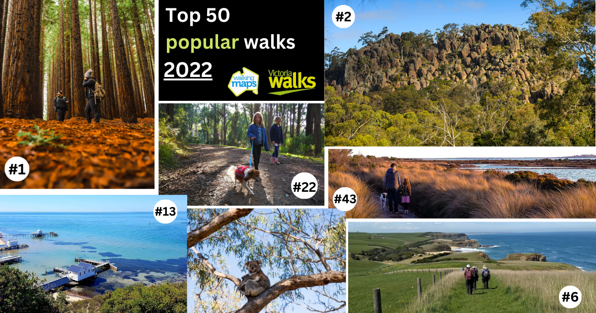
1. Californian Redwood Forest walk, Warburton
Note: This walk is very popular and car parking is limited. See Parks Victoria's Redwood Forest page for tips and updates about facility upgrades and closures.
2. Hanging Rock summit walk, Hanging Rock (near Woodend)
3. Plenty Gorge walk, Morang Wetlands (South Morang)
4. Lerderderg Gorge walk (just north of Bacchus Marsh)
5. Kurth Kiln walk, Gembrook
6. George Bass Coastal Walk (San Remo to Kilcunda)
7. You Yangs East-West Walk (near Little River)
8. Melbourne City Street Art walk
9. Canyon Walk (riverside loop), Bright
10. O'Shannassy's Aqueduct trail, Millgrove to Warburton
11. Green day hike, Frankston South to Mt Eliza
12. The Entrance Walk, Lakes Entrance
13. Sorrento Park to Millionaires' Walk, Sorrento
14. Werribee River Park walk, Cocoroc
15. Maroondah Reservoir Park walk, Healesville
16. Blue Lake loop, Plenty Gorge Parklands, South Morang
17. Merri Creek Trail, Fitzroy North to Coburg
18. Bushranger's Bay Trail, Cape Schanck
19. Lysterfield Park lake circuit, Lysterfield
20. The Pinnacles walk, Grampians National Park (Gariwerd)
21. Maits Rest Rainforest Walk, Otway Ranges (short but spectacular remnant rainforest loop!)
22. Mathias Track and Old Olinda Golf Course loop, Olinda (Dandenongs)
Dogs are permitted on-lead
23. Yarra Bend Park walk, Fairfield
24. Forrest Caves beach walk, Phillip Island
This is a low-tide only walk and observe safety signage (do not enter the water)
25. Raymond Island Koala walk, East Gippsland
Note: A new 1.7km trail has been added since this map was created by our staff
26. Anakie Gorge walk, Staughton Vale
27. Point Addis walk, Great Ocean Road (south of Torquay)
28. Macedon Autumn Leaves walk, Honour Avenue (Macedon)
29. Lake Daylesford circuit, Daylesford
30. Trentham to Trentham Falls walk, Trentham
Note: This 3km (one-way) walk includes roads between the town and the Falls that do not have footpaths.
31. Domino Rail Trail, Trentham to Lyonville (10km return)
32. Beechworth Gorge walk, Beechworth
*33. Wineglass Bay and Hazards Beach circuit, Tasmania
34. Sailors Falls mineral springs short loop, near Daylesford
35. Fairy Cove from Darby River, Wilson's Promontory (Gippsland)
36. Organ Pipes National Park, Keilor North
37. Dog-friendly leash-free community forest walk, Mount Martha
38. Lake Elizabeth walk, (near Forrest, Otway Ranges)
*39. Bondi to Coogee coastal walk, Sydney (NSW)
*40. Mt Ainslie Summit Trail, Canberra (ACT)
*41. Molonglo Gorge, Canberra Nature Park (ACT)
42. Balcombe Estuary Boardwalk Circuit, Mt Martha
43. Edwards Point walk, St Leanoards, Bellarine Peninsula
44. Port Fairy to Griffiths Island walk, Port Fairy
45. Williamstown to Altona bay hike, Port Phillip Bay
This 12km one-way Melbourne walk is public transport accessible (train stations close to start and finish)
46. Buckley Falls upstream walk, Highton (near Geelong)
47. Masons Falls loop, Kinglake National Park, Kinglake
48. Fingal to Cape Schanck and Pulpit Rock, Mornington Peninsula National Park
49. Darebin Parklands loop walk, Alphington
50. Blue Tongue Bend walk, Yarra River, Warrandyte State Park, Warrandyte
Before walking: Check local conditions with the handy links at this Parks Victoria page before setting out. Walk trails may have been impacted by severe weather or other events.
Find walks in any part of Victoria at Walking Maps. Walks rated as a 'Staff Pick' come up automatically when you search by a postcode / suburb, or when you search by name (one keyword).
For more local walk ideas, untick the 'Staff Pick' filter to see maps created by members of the general community (but note these have not been vetted by Victoria Walks staff and may not contain useful information and photos).