Walks in Alpine Shire, Victoria
Walking in Victoria's Alpine region
 Images courtesy: Rob Blackburn for Visit Victoria / David Kirkland for Tourism North East
For digital maps, walk info and photos see the Walking Maps we've created in Alpine Shire by clicking on the names of the walks listed below.
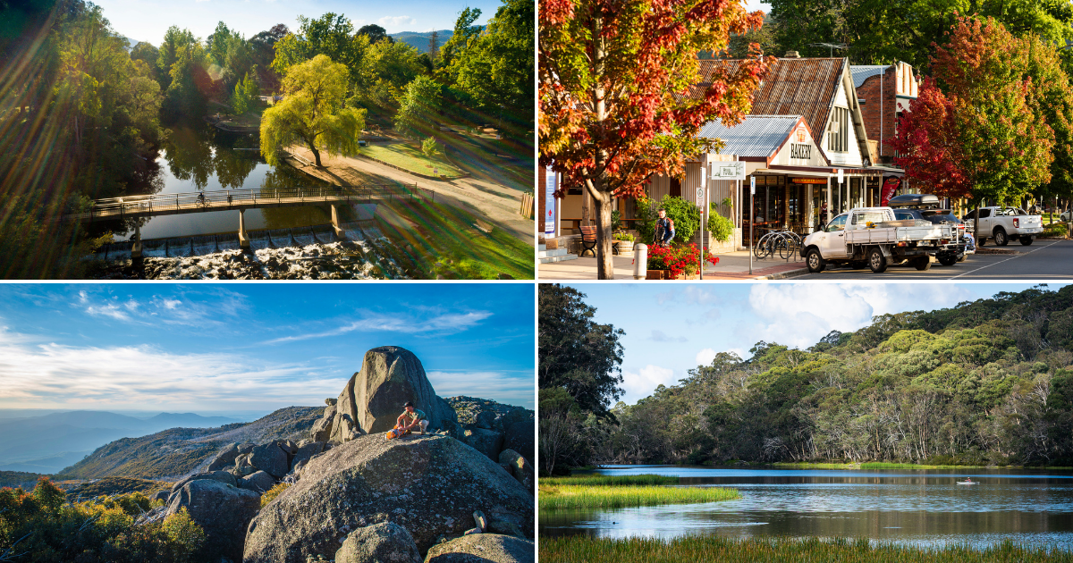
Bright
Canyon walk (3.5km riverside loop walk)
A must-do walk if you're staying in the lovely town of Bright, easily accessible from the town. Follow the Ovens River traversing areas of scenic, historical and natural value. Popular in summer (watch the people on lilos floating by!) and in Autumn when Bright's deciduous trees are at their very best.
The Cherry Walk (5.2km riverside loop walk)
This walk begins from a similar spot to the Canyon walk but heads in the other direction (east) along the river to Cherry Bridge. Though longer, this walk is more accessible with very few steep sections and can be negotiated by those pushing a sturdy pram. The track is mostly packed earth and gravel and is mostly shaded. Click the walk name above for more details and photos.
Bright to Wandiligong (the Wandi Walk) (7.5km one-way)
With mountain views, goldfield history and charming footbridges, the Wandiligong valley is a very pretty place to walk and this route followes Morses Creek. There are many options for the return leg back to Bright. Either follow the same route back or take one of the many footbridges to walk on the opposite side of the creek.
Bright to Porepunkah Rail Trail (6km sealed track, one-way or 12km return)
This neat 6km stretch, the first stage of the of the poplar Murray to Mountain Rail Trail, is popular with walkers as well as people riding bikes. There are plenty of spots to stop and nice views from the river and valley up to surrounding mountains to enjoy.
- You may also wish to explore the small Bright Waterwise Garden in the centre of town with this map created by local volunteers (Upper Ovens Landcare group).
Mount Buffalo walks
The stunning Mount Buffalo National Park is a great place to base yourself with 90km of walk trails to choose from to suit a range of fitness, abilities and tastes.
Lake Catani circuit walk (3.5km loop)
A surprisingly varied walk on the Mt Buffalo plateau, this 1-hour loop is especially beautiful in the warmer months with wildflowers, wildlife and kayak-spotting aplenty!
Chalwell Galleries walk, Mt Buffalo (2.5km return)
Beautiful scenery and rock scrambling adventures await those who undertake this brilliant short walk by Lake Catani.This walk is great for people with a sense of adventure, and many young children will enjoy the challenge - however it's not advisable for those with mobility challenges or who do not feel comfortable in small, tight places!
Mount Buffalo Gorge Heritage walk (2km return)
This is one of the mountain's most popular walks and with good reason. It is short but spectacular, so a great one if you are short on time (or energy)! This walk starts at the very pretty Gorge Day Visitor Area. At an elevation of 1,385 m, Bents Lookout and Gorge Lookout offer expansive views of Ovens Valley and high country. Beyond the visitor centre, the track is unsealed. The path becomes rocky after Crystal Brook lookout. The incline is steep on the return leg making this an easy to intermediate level walk.
The Big Walk (9km one way, steep)
The 'Big Walk' takes you through beautiful and varied habitats as the altitude increases. Stunning views and lookouts make this a memorable alpine experience, but should only be attempted by those with good hiking experience and a good fitness. It is best to arrange transport to meet you at the top, or do a car shuffle as the descent is tough on knees. A memorable walk, well worth doing for those who are up to the challenge!
Cathedral Hump track (2.2km return climb)
Put this varied climb on your Mount Buffalo 'must-do' list as its stunning and varied views make it well worth a bit of huffing and puffing. A highlight is the close-up, awe-inspiring sight of the craggy, granite 'Cathedral'. Then head up to the Hump, and while it may be tempting to stay for sunset, allow yourself plenty of time (and light) to make your way back down the winding, rocky paths to the picnic area.
Rollasons Falls walk, Mt Buffalo (2.5km return)
A gorgeous walk down through a Eucalypt forest to the two-tiered Rollasons Falls and swim hole on beautiful Mount Buffalo.
Myrtleford and Porepunkah walks
Myrtleford Mosaic Trail (also known as the Ovens River loop walk, 5.3km)
Thanks to two local artists this lovely walk along the Ovens River is home to 70 mosaics, hidden along it (probably more since this map was created!) How many can you find?
Myrtleford Threatened Species Mosaic Trail, Reform Hill
Myrtleford's new mosaic trail is located at a former goldmine site, now rejuvinated by Myrtlyford Landcare group and local artists into a fabulous, educational walk experience. This loop trail is 3.1km. It is unsealed and does have some stairs.
Porepunkah riverside loop
A pleasant 3.5km riverside stroll in lovely little Porepunkah, near the foot of Mount Buffalo and just 6km from Bright. This walk starts at Riverside Park, just off the main street; very popular in summer as it has a patrolled river pool (and a toddler's wading pool built into the bank). The walk heads back into town along the Murray to Mountains rail trail and past a popular cafe.
Mount Beauty walks and Tawonga South
Pebble Beach river walk, Mount Beauty (4km return)
This easy, flat walk follows a sealed track along the eastern bank of the lovely Kiewa River. Beginning 100m north of the Visitor Centre the track becomes more shaded as you approach the 'beach' - a wide, inviting stretch of the river popular with swimmers during the warmer month. Pack river shoes as well as your swimwear if you want to cool off, as the rocks are slippery (and painful!) to walk on. See walk link above for photos, map and more information.
Harrietville and Hotham
Harrietville's Tronoh Dredge Hole circuit (2.3km walk starting in town)
If you're in need of a gentle, easy stroll (followed by a swim!) then this is a perfect summer option. This is one of the short walks in the 13.5 hectare Tronoh Lake Reserve south-east of the Harrietville township. The approach to the lake is through a small forest of towering pines and in summer the bank is teeming with family and friendship groups. See the map link above for more details.
More information about walks in Victoria's Alpine region
For more information about walking in Alpine Shire head to this page. and please note that for printed maps PDF brochures of many of these walks are available at this link.