Guide to Measuring Walking
Victoria Walks commissioned consultants to prepare a Guide to Measuring Walking. Our discussions with councils suggested this was one of the most difficult issues for them.
Measuring Walking - a Guide for Councils explains the issues and options for measuring pedestrian activity, looks at the advantages and disadvantages of various methods, provides recommended approaches to common scenarios and outlines a range of Victorian case studies.
In addition to the examples in the Guide, we have provided two examples of pedestrian surveys here:
- An example of a walking participation survey, provided by Moonee Valley City Council.
- An example of an intercept survey for a suburban activity centre - used in Camberwell by Boroondara City Council.
Walking information
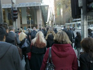
Data on walking is limited, prompting the Department of Transport to note "the lack of sufficient information on walking rates and patterns means that we can not adequately measure exposure rates for traffic related walking accidents" (presentation to Parliamentary Inquiry into Environmental Design and Public Health, 6th September 2011).
The census only records travel to work and this tends to downplay the significance of walking. In Melbourne 3.4% of trips to work are made on foot, but 13% of total trips are walked.
The Pedestrian Access Strategy provides the best snapshot of walking in Victoria, albeit based on data from 2007/8. This indicates:
- The average walk trip in Melbourne is approximately 1 kilometre and 23% of walk trips are over 1.6 kilometres.
- In Melbourne City and Yarra, approximately 70% of short trips (under 2km) are walked.
- In other inner areas like Maribyrnong, Port Phillip, Stonnington and Moreland more than 50% of short trips are walked.
- In the outer metropolitan areas of Melton, Hume, Whittlesea, and Nillumbik 26-27% of short trips are walked and only 16% of trips in Cardinia.
Data sources
- The census records travel to work, but does not record walking in combination with other modes, such as public transport. Victoria Walks has made submissions to the Australian Bureau of Statistics requesting that this be recorded in the 2016 census, along with travel to education.
- The Victorian Integrated Survey of Travel and Activity (VISTA) provides the best data on travel including walking for Victoria, although the data is not provided in summary form for the latest survey.
- In 2012 the Federal Government released a report, Walking, Riding and Access to Public Transport, which provides a useful picture of walking and cycling trends across Australia.
- Public Transport Victoria records information on how passengers access individual train stations, which are major walking destinations.
Walkability audits
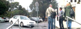
Assessing the walkability of urban areas and making resulting improvements is an important component of promoting walking.
Victoria Walks provides an easy to use Walking Audit tool, which can potentially be used by the public as well as professionals. A more technical model is provided by the Western Australia Department of Transport Walkability Audit Tool.
Case studies
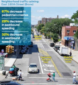
The value of measuring the impact of council activities in communicating success and the need for change is illustrated by New York City's Measuring the Street.
In 2007 Darebin City Council surveyed 100 shoppers at Fairfield Village, a middle suburban centre in Melbourne. Amongst other things, they found that walking (32%) was the most common form of travel to the centre, followed by car (27%) and train (21%). They also surveyed local residents and found 69% said they usually travelled to the shops by walking. Of those who walked to the centre, 65% listed convenience as the reason for their choice.
Darebin City Council also conducted intercept surveys at Reservoir shopping centre - further from the CBD - in 2010. The number of drivers was higher, but still less than half of those present (42%), while 28% walked.